- This page contains affiliate links. Purchases made through them may earn us a small fee.
Getting to Shenandoah National Park
Driving to Shenandoah
There are four access points to Skyline Drive, the main road through Shenandoah National Park. From the north, take US-340 south from I-66 to the Front Royal Entrance. From the east or west, take US-211 to the Thorntop Gap Entrance. US-33 offers another east/west crossing of Skyline Drive further south, at the Swift Run Gap Entrance. From the south, take US-250 from I-64 a short distance to the Rockfish Gap Entrance. This is also the northern starting point of the Blue Ridge Parkway, a 469 mile long scenic highway connecting Shenandoah and Great Smoky Mountains National Park.
If you’d like to plot directions from your location use the interactive map below. The marker shows the location of the Harry F. Byrd, Sr. Visitor Center at Big Meadows in Shenandoah.
Flying to Shenandoah
Shenandoah is only an hour from the major urban center of Washington, DC. The three airports below are all located around this central area. For each airport we provide direct links to browse available flights and cars. For price searches, simply enter your origin and dates.
Washington Dulles International Airport (IAD)
Located in Dulles, Virginia, 57 miles by car to Shenandoah
Washington Dulles flight schedule and price search
Washington Dulles available rental cars and price search
Ronald Reagan Washington National Airport (DCA)
Located in Arlington, Virginia, 73 miles by car to Shenandoah
Washington National flight schedule and price search
Washington National available rental cars and price search
Baltimore/Washington International Thurgood Marshall Airport (BWI)
Located in Baltimore, Maryland, 106 miles by car to Shenandoah
Baltimore flight schedule and price search
Baltimore available rental cars and price search
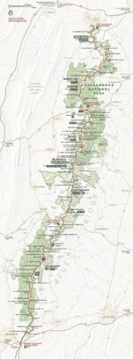
Official Park Map
Below is the official park map provided by the National Park Service. You can view either the original PDF file or a simple JPEG image file (some of these files can be quite large). Note that while this map is useful for general navigation around the park, if you plan to do any hiking, you should really have a proper Shenandoah Trail Map.