- This page contains affiliate links. Purchases made through them may earn us a small fee.
Getting to Pinnacles National Park
Driving to Pinnacles
There are two entrances to the park, on the east side and the west side. There is no road within the park that connects the two sides. The road within the park is California Highway 146. The east entrance is reached off of California Highway 25. The west entrance is off of US Highway 101 at the town of Soledad.
If you’d like to plot directions from your location use the interactive map below. The marker shows the location of the Pinnacles Visitor Center.
Flying to Pinnacles
Below you will find a list of airports most convenient for a trip to Pinnacles, listed in order of distance. For each airport we provide direct links to browse available flights and cars. For price searches, simply enter your origin and dates.
Monterey Regional Airport (MRY)
Located in Monterey, California, 50 miles by car to Pinnacles west entrance
Monterey flight schedule and price search
Monterey available rental cars and price search
Norman Y. Mineta San Jose International Airport (SJC)
Located in San Jose, California, 79 miles by car to Pinnacles west entrance
San Jose flight schedule and price search
San Jose available rental cars and price search
San Francisco International Airport (SFO)
Located in San Francisco, California, 112 miles by car to Pinnacles west entrance
San Francisco flight schedule and price search
San Francisco available rental cars and price search
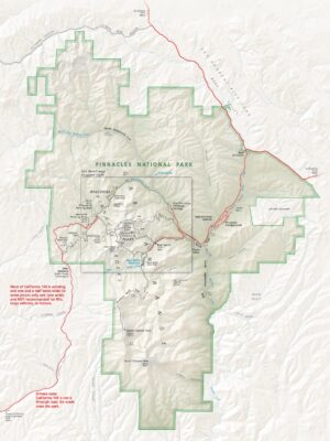
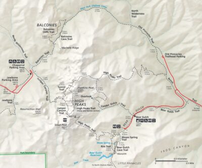
Official Park Maps
Below are the official park maps provided by the National Park Service. You can view either the original PDF file or a simple JPEG image file (some of these files can be quite large).