- This page contains affiliate links. Purchases made through them may earn us a small fee.
Getting to Gateway Arch National Park
Driving to Gateway Arch
Gateway Arch National Park is on the Mississippi River, right in the middle of downtown St. Louis. This is nothing like a typical national park. The city of St. Louis is accessible from all directions via a plethora of highways, including Interstates 44, 55, 64, and 70.
If you’d like to plot directions from your location use the interactive map below. The marker shows the location of the Gateway Arch National Park.
Flying to Gateway Arch
Below you will find a list of airports most convenient for a trip to Gateway Arch, listed in order of distance. In this case, St. Louis is the obvious choice, being so close and having so many flights. For each airport we provide direct links to browse available flights and cars. For price searches, simply enter your origin and dates.
St. Louis Lambert International Airport (STL)
Located in St. Louis, Missouri, 14 miles by car to Gateway Arch
St. Louis flight schedule and price search
St. Louis available rental cars and price search
Columbia Regional Airport (COU)
Located in Columbia, Missouri, 134 miles by car to Gateway Arch
Columbia flight schedule and price search
Columbia available rental cars and price search
Indianapolis International Airport (IND)
Located in Indianapolis, Indiana, 231 miles by car to Gateway Arch
Indianapolis flight schedule and price search
Indianapolis available rental cars and price search
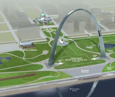
Official Park Map
Below is the official park map provided by the National Park Service. You can view either the original PDF file or a simple JPEG image file (some of these files can be quite large).