- This page contains affiliate links. Purchases made through them may earn us a small fee.
Getting to Great Basin National Park
Driving to Great Basin
With the exception of the tiny town of Baker, Great Basin is far from civilization. US-50, nicknamed “America’s Loneliest Road” for good reason, runs east and west through Nevada. NV-487 leads south five miles from US-50 to the town of Baker and the park entrance.
If you’d like to plot directions from your location use the interactive map below. The marker shows the location of the Lehman Caves Visitor Center in Great Basin.
Flying to Great Basin
Below you will find a list of airports most convenient for a trip to Great Basin, listed in order of distance. For each airport we provide direct links to browse available flights and cars. For price searches, simply enter your origin and dates.
Harry Reid International Airport (LAS)
Located in Las Vegas, Nevada, 243 miles by car to Great Basin
Las Vegas flight schedule and price search
Las Vegas available rental cars and price search
Salt Lake City International Airport (SLC)
Located in Salt Lake City, Utah, 306 miles by car to Great Basin
Salt Lake City flight schedule and price search
Salt Lake City available rental cars and price search
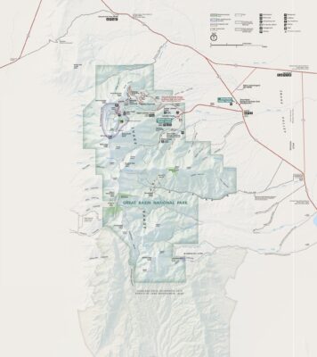
Official Park Map
Below is the official park map provided by the National Park Service. You can view either the original PDF file or a simple JPEG image file (some of these files can be quite large).