- This page contains affiliate links. Purchases made through them may earn us a small fee.
Getting to Wind Cave National Park
Driving to Wind Cave
The main park road of Wind Cave National Park is US-385. The town of Hot Springs is about six miles south of the park boundary. Jewel Cave National Monument and the city of Custer are to the north. SD-87 also enters the park and joins the main park road. Custer State Park is on the way.
If you’d like to plot directions from your location use the interactive map below. The marker shows the location of the visitor center in Wind Cave.
Flying to Wind Cave
With the exception of Rapid City, Wind Cave is far from airports of any size.
Below you will find a list of airports most convenient for a trip to Wind Cave, listed in order of distance. For each airport we provide direct links to browse available flights and cars. For price searches, simply enter your origin and dates.
Rapid City Regional Airport (RAP)
Located in Rapid City, South Dakota, 63 miles by car to the Wind Cave Visitor Center
Rapid City flight schedule and price search
Rapid City available rental cars and price search
Denver International Airport (DEN)
Located well east of Denver, Colorado, 347 miles by car to the Wind Cave Visitor Center
Denver flight schedule and price search
Denver available rental cars and price search
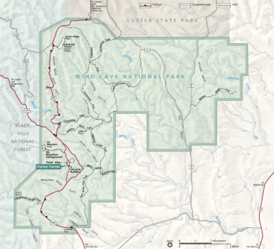
Official Park Map
Below is the official park map provided by the National Park Service. You can view either the original PDF file or a simple JPEG image file (some of these files can be quite large). Note that while this map is useful for general navigation around the park, if you plan to do any hiking, you should really have a proper Wind Cave Trail Map.