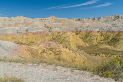
The Roads of Badlands
Badlands National Park is divided into two main sections, the North Unit and the South Unit, also known as the Stronghold Unit. The latter is accessible only by unpaved roads, and is managed by the Oglala Sioux Tribe. The North Unit is by far the more visited area, for two reasons. First, the area is easily accessed by the Badlands Loop Road, 28 miles of which traverse the park. The second is its proximity to I-90, exit 131 on the eastern end and exit 110 on the western end, in the town of Wall. We cover the Badlands Loop Road below in two sections.
Start Point: Mile 0 – Pinnacles Entrance Sign
End Point: Mile 13.7 – Panorama Point
Start Point: Mile 13.8 – Panorama Point
End Point: Mile 28.2 – Northeast Entrance